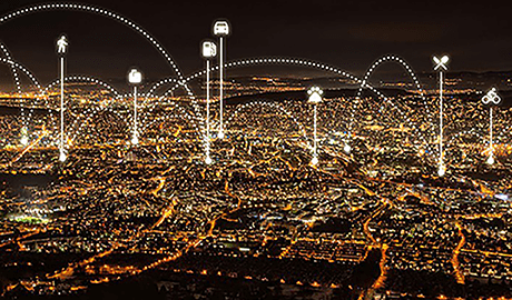
Big data
Understanding the present and shaping the future
The first cities in Switzerland have started using anonymised mobile network data to allow them to evaluate infrastructure projects better. The Future Cities Laboratory at ETH in Singapore is going a step further. It is using big data and a simulation of the entire urban population to optimise planning for complete infrastructure networks and neighbourhoods.
Daniel Meierhans
How should limited financial resources be used best? All major Swiss cities are facing the same challenges. The agglomerations continue growing. Density is increasing, new urban districts are being built, and an influx of inhabitants is transforming existing neighbourhoods. The transport infrastructure of the future needs to satisfy more than just the new mobility requirements. To ensure that the growth occurring at present remains sustainable, the quality of life enjoyed by inhabitants also needs to be improved in the increasingly compact city centres. For Kay Axhausen, the head of the Institute of Transport Planning and Systems at ETH Zurich, one thing is perfectly clear: “Infrastructure that won’t be fully utilised for another 40 years, as was the case in Switzerland in the 1950s when, among other things, the motorway network was planned with foresight, are no longer realistic today.”
"In order to be able to decide which of these cost-intensive projects make sense, those responsible at administrative level – and, in the final instance, the voters – depend on reliable data."
Data as a basis for investments worth billions
Specifically, there are projects in Zurich, Basel, Geneva and Lausanne currently being discussed, or on which work has already started, which amount to several dozen billion Francs in volume. Along with expanding the pedestrian and cycling networks, these also include new tram and commuter rail lines, the construction of new bypass roads, tunnels under the inner cities or the crossings above and below lake inlets. In order to be able to decide which of these cost-intensive projects makes sense, and how they are best implemented, those responsible at administrative level – and, in the final instance, the voters – need reliable data.
Mapping the dynamics of urban life
The city of Geneva recognised the potential that big data offers for urban planning projects like this back in 2011. The pilot project “Ville Vivant” convincingly demonstrates how realistically dynamic data from mobile phones are able to map the dynamics of urban life. The technology has meanwhile progressed even further. The first Swiss cities, such as Pully, are using the mobile network for fact-based transport planning. The main advantages of mobile phone movement profiles: They can create a practically complete map of mobility, data collection is comparably inexpensive, and the data are available with a minimum of delay.
Inaccurate surveys
In the past, the cities relied on surveys such as the federal Mobility and Transport microcensus. Surveys like this can only be conducted every few years due to their cost, and there are, by principle, inherent uncertainties associated with them. Both the questionnaire and random sampling have limitations. They also fail to reveal non-standard patterns of behaviour and new questions arising over the course of the analyses remain unanswered. Add to this that people, by nature, tend to give the most positive impression of themselves possible in response to the questions.
The uncertainties reflected in today’s transport models are correspondingly large. Anonymised and aggregated mobile phone data from the mobile network, in contrast, provide a practically exhaustive, and an up-to-date, representation of reality. “Comparing the previous models with our data reveals striking differences,” as David Watrin, who is responsible for security and intelligence products at Swisscom, determines.
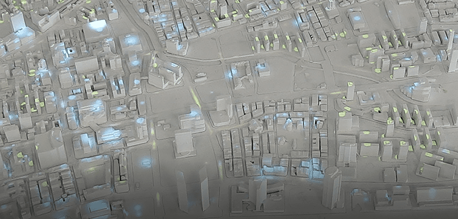
Simulating each and every inhabitant
Just how great the potential offered by data analyses like this is, not only for transport, but for all areas of urban planning, is shown by the work pursued at the Future Cities Laboratory at ETH Singapore. In 2016, the city again leads the global smart cities ranking according to Juniper Research.
Transport engineers, architects, sociologists, energy experts, designers, development planners and modelling experts are all working together in the Future Cities Lab on solutions for the city of the future. To do so, they utilise sophisticated models such as MATSim Singapore (Multi-Agent Transport Simulation) in which the specialists working around Axhausen register overall mobility in the Asian city state.
Each of more than 5 million inhabitants is mapped in this simulation as a software agent with individual characteristics. These are sourced from the statistics available covering places of residence, workplaces and population structures, from the results of surveys, and from the user profiles of the mobile smartcards used in Singapore to automatically bill passengers travelling by public transport. “The many interdependencies between the different elements, when examined individually, quickly become overcomplicated. Using models allows us to understand them,” as Axhausen explains.
Factoring in behaviour
The fact that the ETH researchers are not only simulating the entire mobility system in the MATSim model, but also the behaviour of the population for the first time, allows them to obtain important additional information. Among other things, they can estimate how passengers will react to a change of services. In Singapore, the researchers used the computer to simulate how a very long bus route, on which there are constant deviations from the timetable, can best be split up. By splitting the route into two sub-sections, not only the timetable could be stabilised. The improved service also allowed the line – as predicted in the models – to regain passengers that it had lost beforehand.
Functional living environments
Public and private transport that functions as smoothly as possible is not the only decisive criterion for an attractive city. Equally important are attractive pedestrian zones in which the neighbourhood can come to life. In this case, simulations can also make a decisive contribution to ensuring plans result in living environments that function in practice. How can overpasses and underpasses for roads best be integrated into a pedestrian network? Which type of streetscapes act as barriers to pedestrians? When are shops or streetside cafés necessary to attract passers-by? How should a park in the surrounding area be laid out so that it provides a space for people to rest and relax? The reactions of the virtual inhabitants show which variations within the overall interplay of the full urban ecosystem are highly promising, and which are unlikely to function.
Intervening at short notice...
At the moment, Axhausen sees the greatest benefits of big data in the opportunity to intervene in events at short notice: “You can identify changes immediately and therefore react promptly.” Specifically, the dynamic data from mobile phones allow traffic jams, or problematic crowd situations, among other things, to be identified at an early point in time and be predicted within a certain period of time. In Swiss cities, the way traffic lights are controlled can be improved, for example, as Watrin explains: “Our data don’t just register the main thoroughfares, as today's fixed count sensors do, but rather all roads. This makes the image of the traffic situation much more complete.”
...and make continual improvements
The fact that big data makes changes visible with immediate effect also gives urban planners another, highly effective instrument to use: In a similar way to how Google and other major website operators are today gradually improving the usability of new functionalities by means of real-time analysis, urban planners will be able to continually optimise infrastructure networks and neighbourhoods in future. The mobile network data quickly reveal which measures achieve the desired effect and which don’t, and also make changes in the use of urban environments visible much more quickly. Within the framework of the national research program “Big Data” (NFP 75), ETH is launching a corresponding project that should reveal how the data can also be used for long-term planning.
Improved transport planning in Pully
The community of Pully in the canton of Vaud is utilising aggregated mobile network data for transport planning. Four major traffic routes lead through the city – Pully is severely affected by transit traffic. In order to improve the traffic situation, to make accessing the city centre easier and to improve the quality of life for its approximately 16,000 inhabitants, Pully has joined forces with Swisscom to implement a project that functions as a role model. Working together on its development yielded a planning method for improved infrastructure and transport planning that makes flows of traffic clearly visible in their entirety on the basis of the mobile network data. For future applications, Swisscom is also working in close cooperation with higher education institutes in order to develop further simulation models.
More on the topic